 One of the birds on the lake is the Giant Coot.
They pulls weeds together into piles in the middle of the lake for nests.
 We ate lunch at the lake. Nearby were these strange plant/rock formations. The platter on top is a harder rock that is resting on some of the softer, stratified lower rock and the plant.
The plant seems to grow like coral. The inner part is all branches, the outer this solid green mass of leaves.
 Almost the only other wild animal we saw up here was the Andean Rabbit or Viscacha. It is not a rabbit at all, but a chinchilla! The viscacha found in Bolivia looks more rabbit-like than the ones found in the Argentine pampas.
It is typically found in rocky outcrops, where it spends a lot of the day sunning itself. If you look really closely at the picture you will see the very long whiskers - which reach almost to its feet when sitting.
The Salt Hotel
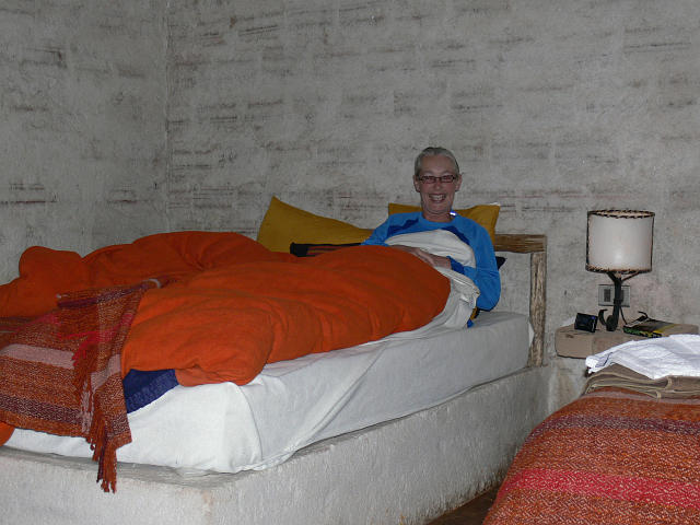 We stayed on night at the salt hotel in the town of Tunupa.
Blocks of salt sawn from the salt flats form most of the structure of the hotel. Instead of a box spring under the mattress, there is a huge block of salt. The walls are salt. Almost everything is salt except the shower - which is faced with a black slate.
Again, this hotel is owned and staffed by the community. Again, inside temperatures track outside temperatures - not getting quite as hot as outside, or as cold. We woke up to 12.5C here. Sounds cold, but it is survivable.
Again, it tries to be eco-friendly. This means it is off the power grid. This means we got 3 hours of electricity from 7 to 10pm.
 The salt hotel looks conventional from a distance - thatch roof the only slightly unusual aspect.
We are still in the desert - a few bushes, but little or no grass and almost no trees.
 The next day we head up the volcano to a cave which contains the mummified remains of 7 people.
The body is placed in the foetal position (getting ready for rebirth) and supplied with some small pots of food.
Very interesting.
To top this bit off, while we were in the cave we heard the wingbeats of a hummingbird. Why would a hummingbird be in a cave? We located the nest it was visiting - there was one adult bird sitting on the nest.
The bird was an Andean Hillstar. We got no really good pictures of this bird - it spends very little time at any one flower and no one thought to put out feeders (even the Salt Hotel, which tries to be eco-friendly) had no feeders.
The Salt Flats
 The Uyuni Salt Flats are roughly circular with a diameter of 60 kilometres. The depth of salt varies, from almost nothing at the shoreline to 60 metres in some places.
There is a river flowing from Lake Titikaka to these salt flats, but no exit river. There are a lot of minerals in the surrounding area - the mine Borax in the hills. The fresh water entering the lake area has brought along salt for millions of years. The water evaporate each dry season (it is dry from April to October), leaving the salts behind.
This picture shows the pattern of dried salt - hard to see in two dimensions, but it looks like snow or ice.
 The drying process produces this roughly hexagonal shapes all over the surface. Pretty weird.
 This is the original salt hotel - not much used now and the only one that is actually on the salt itself.
A local family operates a small store and a kind of salt museum in the almost derelict structure.
Lake Titikaka

The owner of this small roadside attraction helped Thor Heyerdahl build the rafts he used in his attempt to sail from South America to the Polynesian Islands.
The reeds, and it takes thousands to make a big boat, all come from the lake.
 This is the vibrating chair the gave us for a van for the two 12 hour drives. This drive, from Uyuni to Copacabana on Lake Titikaka left me feels completely enervated. I could walk, but not much more than that.
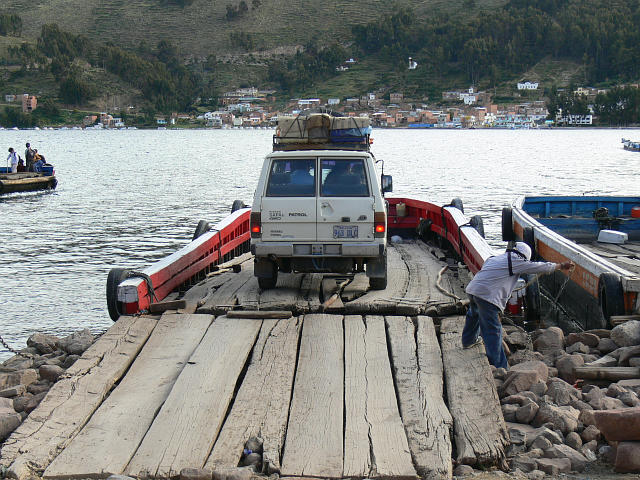
Here the van is on a small ferry to make a short crossing of Lake Titikaka. The land around the Bolivian part of the lake is very hilly - this short ferry ride is the only option.
The ferry is powered by a 40 horsepower outboard. The ferry is locally made, of course. Is BC Ferries paying attention? Their monopoly could be a risk.
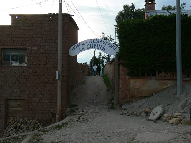 We stayed two nights at the Hostel La Cupula in Copacabana. Great food and Bolivian prices!! Others visiting this area stay with the locals - a bare room, no heat, no shower. We really enjoyed this place.
 Isla del Sol
Isla del Sol was one of the sacred places to the Inca. The first Inca was said to have been raised out of Lake Titikaka in around 1,000 AD. The raising was in this area.
 As well as a visit to some ruins and an altar, we walked from the north end of the island all the way to the south end - some 10 kms. Although the elevation gain was not large - 150 metres at most - it was a considerable effort owning mostly to the thin air. We were very tired when we finished. The Inca trail puts 3 hikes like this in a row. We are a little worried.
 Speaking a ferries - this is the only large boat we say on the lake. Apparently it was built on the Bolivian side by a former Premier of BC. Our guide could not remember his name.
All the local boats used to move people back and forth are much more rustic than this. As well, like most drivers of cars in Bolivia and Chile, they drive much more slowly than we would. Our ferry travelled at about 5 knots for the two hours it took to reach the north end of the island. Powered by two 80 horse outboards in an open well at the back, the engine fumes added to the fun of the slow ride to the island.
|  Our Bolivia time was spent in 3 places, plus travel (all by car).
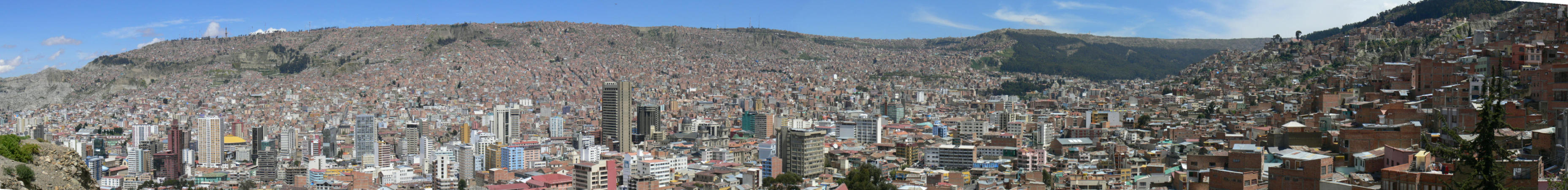 This is a panorama taken from a viewpoint overlooking La Paz. The downtown is surprisingly modern, with lots of nice medium-rise buildings. This panorama is about 3 screens wide - you will have to mouse around a bit to see it all. At the far right you can see the typical red-brick buildings that people live in.
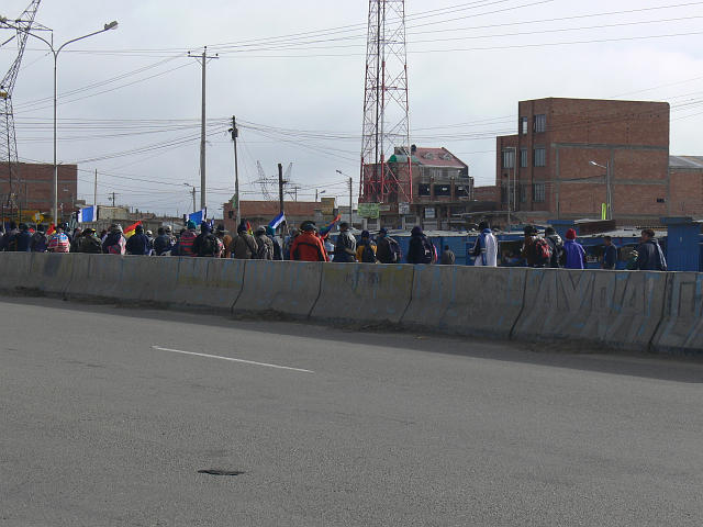 Political Problems
 La Paz to Uyuni
It is over 500 kilometres from La Paz to the desert area southwest of Uyuni we were going to explore. We decided to travel by car so we could stop and look at whatever interested us. This is the vehicle Bolivian Specialist provided. Right now it is stopped while the drive replaces the flat tire. The vehicle is a noisy diesel with no shocks. We were travelling on paved roads at this point so it was not too bad. The second half of the trip is on dirt roads and it was terrible. A total of 13 hours on a vibrating chair.
La Paz to Uyuni
It is over 500 kilometres from La Paz to the desert area southwest of Uyuni we were going to explore. We decided to travel by car so we could stop and look at whatever interested us. This is the vehicle Bolivian Specialist provided. Right now it is stopped while the drive replaces the flat tire. The vehicle is a noisy diesel with no shocks. We were travelling on paved roads at this point so it was not too bad. The second half of the trip is on dirt roads and it was terrible. A total of 13 hours on a vibrating chair.
 The main goal of our time in Bolivia was to the the high plane and the salt flats.
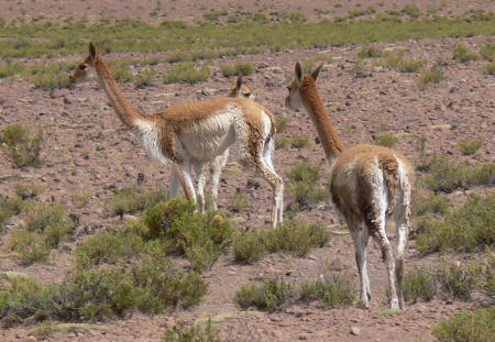 There are 4 camel type animals in Bolivia, two that have been domesticated (llama, alpaca (a small llama), two that are wild (vicuna and guanaco). We saw lots of these vicuna during the next few days. We saw no guanaco.
 At the town of Oruro we left the paved road and started of 7 hours of gravel road.
 This is a typical farm residence on the high plateau. One small rectangular house per family, usually made of adobe - mud and straw. The small building in the middle with the round roof is the oven - used to make bread.
 The sun is setting and we are still driving along the dirt road in the old Toyota Land Cruiser with no shocks. We had only one other problem with the vehicle - a reported failure of a spark plug wire. Do diesels have spark plug wires?
 No one can see, or take, too many sunset pictures - can they?
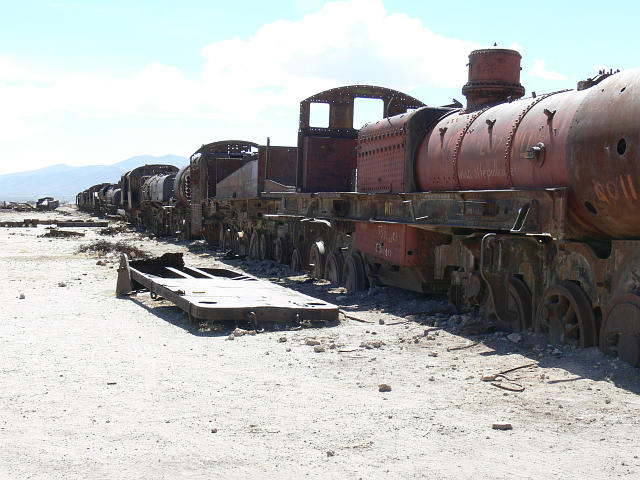 The smallish town of Uyuni is the standard home base for exploring the area. The first stop of the tour is the train graveyard just outside town.
 We did spot a use for these train skeletons though - a bird had a nest in the cab of one of the locomotives. (A Bright-rumped Seed Finch).
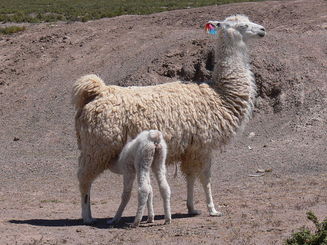 We happened on this llama feeding its young. We saw a number of very young llamas. Perhaps they have young at the end of the rainy season.
 Our driver was hunting around while we were looking a birds near a small boggy area and came up with this wild potato. The ground where he was hunting look barren. He looked for a slight circular lifting, perhaps caused by the sprouting of the potato, then dug down about 10 inches to the plant.
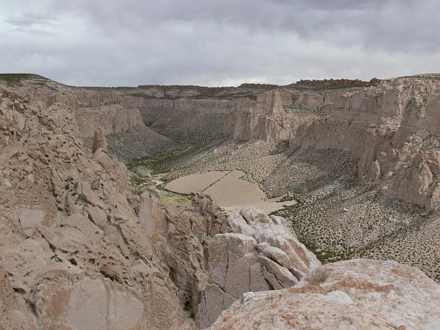 Our next stop was this fabulous eroded canyon. Lava from a nearby volcano (there is always a volcano nearby in this area, although almost all have been quite for the last 30,000 years) capped sandstone and delayed erosion of areas around the rim.

 Laguna Colorado
 While we were looking over the flamingos, trying to find some Chilean Flamingos (the least common in the lagoons we stopped at), this Andean Fox trotted by.
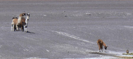 However, this small group of llamas, which included 2 or 3 young, was not taking any chances. They formed a ring around the young and sent one out (presumably the male) to challenge the fox. You can just see the fox in the bottom right of the picture.

 Laguna Colorado
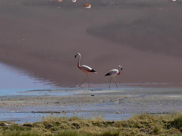
 This is the Puna Flamingo. Less black at the back, a few red feathers back there, less red in the neck, but some on the upper breast, are the best field marks at a distance (at least for the birds we saw).
 We spent two nights at Hotel del Desierto. It is near a junction in the desert roads called Ojo del Perdiz, but tourists would be hard pressed to find the junction - there is nothing there at all.
