The Challenge
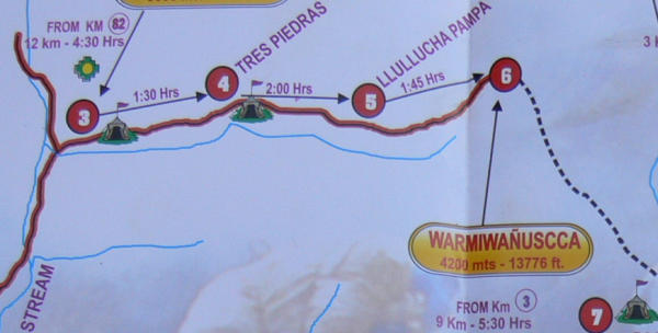
 As you can see from the map, the hike along the Inca Trail is about 45 kilometres over 3 and a bit days. But that is not the challenge.
As you can also see from the map, there is considerable elevation gain as well.
Day 1 - Piscacucho to Wayllabamba
 The day begins early in Cusco with a taxi to the bus pickup point, the bus to the end of the road at Piscacucho (also known as kilometre 82 of the Cusco to Aguas Calientes railway). Here we piled out, and readied ourselves for our walk.
Our first critical decision was to have someone else carry our heavy pack, leaving us with only a light pack with nuts, candies and water. This is expensive and sounds a little lazy. Had we not done this we may not have been able to do the walk. (Most of our stuff we left at the hotel in Cusco. Our heavy pack had extra clothes, rain wear, books, and of course my laptop.)
This first part of the trail has been rebuilt by the parks people, so does not contain the actual stone paving laid down in Inca times. Unfortunately, in rebuilding someone in authority decided that most of the people using the trail would be tourists - those huge Europeans. For once, they overestimated the appropriate size - the steps are quite high.
 The inocents begin - Brenda on the bridge over the Urubamba River, just after passport control at the start of the hike.
It is sunny, but not hot. We are at altitude 2,750 metres here (9000 feet) which keeps it cool. It also means that the air has no oxygen! Even small efforts require a lot of breathing. Simple things like taking a picture - I always hold my breath to help steady the camera - leave you panting.
You can perhaps see in the background that this area is pretty dry. So, around 10 am we started out walking along a dry stoney path in a cool dry desert. There are 11 tourists in our group - 5 Argentinians under 30 and all pretty fit as well as 4 Brits and 2 Canadians. The age breakdown of our group is 7 under 30, 4 over 50.
Overall, 250 tourists and 250 porters start the trek each day. Most of the tourists are under 30. Most are from Europe, with only a few Canadians and fewer Americans.
 Although this area looks pretty rugged, it is actually mostly farmed by indigenous Andean people. They have small fields of corn and keep animals, as well as making a few Soles selling water, pop, and beer to the trekkers.
The trail is wide, dirt and rock, exposed to the sun all day long.
So, easy walking but sunny.
There are big mountains on all sides all day long. Most the the mountains have been worn down over time to round topped hills. In fact, most of these hills are not rocky mountains but dirt and gravel mountains.
Because the area is farmed there are no real trees at all - all have been used up for firewood over the years. Flora and fauna is pretty limited - interesting, but not fabulous. The mountains are doing the heavy lifting scenery wise on this section.
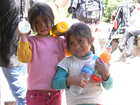 The andean people have regular stops at which they sell trinkets, water, juice and beer.
These girls live a long way from the last power line - in fact they live in a very remote area. However, every day they sell pop and water to trekkers - so they get lots of contact with wealthy, first-world people, even if most of that contact is with people between 20 and 30.
Our trek was one of the least expensive. Some cost twice as much, some much more. (The most expensive trek included individual plastic wash basins outside the cook tent at the end of each section. I expect their food was better than ours as well.) Even our tour is too expensive for most backpackers. It looked to me like most of the hikers were fairly well off - or the children of the well off.
Quite a shock for these young girls, from families that may have a cash income per family of around $1,000 per year to meet up with 20-somethings spending more than that on this hike.
 Early in the first day hike we reached the top of a small hill and looked down on this ruin from Inca times called Llaqtapata.
If you follow the middle line of terraces to the right you see some brush. That is what the site looked like before the restoration work began - taken over by brush and looking like any other part of the hillside. It took archeologists from the US, working in the area in the 1920s to find these sites and begin the restoration work. Most restoration today is done by Peru.
 The first campsite, and perhaps the best.
Yep, we slept on the ground in small, two-person tents. We rented sleeping mats and sleeping bags from the trek company. We might have done better renting in Cusco (better equipment because we could check it out beforehand), but then we would have had to carry them!
This site has grass - a not too uncomfortable spot.
Better yet, this campground is at about 3,000 metres - under 10,000 feet. At this altitude sleeping is not a problem for us after almost 3 weeks at this and higher altitudes. For people who had not had time to get used to the altitude, this is high enough to cause problems sleeping.
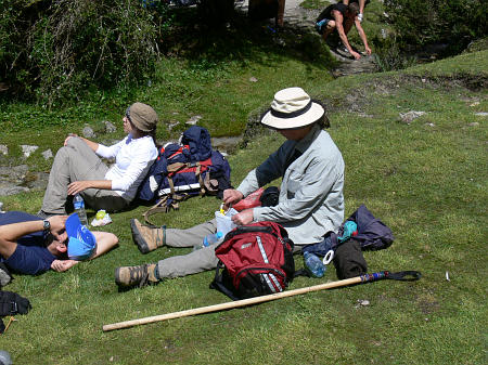
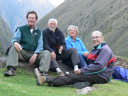 Minutes after we dropped our packs in our tents, Nigel (second from left) suggested a beer! We headed up to the small Inca site, pulled up a couple of rocks and got to work. We are close enough to civilization that the beer is actually cold! This was our last beer of the hike.
Nigel and Judy (now both retired) are finishing up a 3 month round the world tour. They had just come from New Zealand where they had done the Milford Trek - a 3 day trek on the west coast of the South Island. A warm up for the Inca Trail. We were all feeling pretty cocky at this point.
I think we were all pretty relieved that there was someone else to keep us company at the back of the pack.
 In addition to the 11 hikers, we had 9 porters and two guides.
One of the Argentinians talked with one of the porters and got the wage scales for this work. It turns out they make about 70 Soles (less than $30) per hike and they have to pay some of their expenses (the train ride back, for example). As soon as they finish one trek they are back to the labour exchange at the start, trying for another trek.
This meeting on the first night is to introduce the porters and explain how important tips are to them.
Perhaps those on more expensive treks are spared this. After introducing the porters, our guide as each of us to introduce ourselves. Nigel admitted to being 69. I admitted to being 29.
Each morning after the hikers leave the camp ground, the porters pack up everything into large packs and head off up the trail after us. Since they have to be to the lunch area before us so they can set up the cook and eating tents, and cook the lunch, they have to go faster than we do. In fact, they have to move pretty quickly.
Most hikers move along at about the same pace - some a little slower, some a little faster. We rarely passed other hikers and were rarely passed by hikers. However, every couple of minutes we were passed by porters. This means that you are rarely alone on the trail for more than a few minutes. This detracts a little from the Zen of the hike.
Day 2 - Wayllabamba to Pacaymayu
 We knew this was the climb day, but we were not ready for the effort required.
- Up at 6am, breakfast at 6:30, hike starts at 7:00 at 3,000 metres.
- Reach the top at 12pm, at 4,200 metres. The trail goes up 1,300 metres in 9km!
- Descend 600 metres over the next 2 hours to our campground.
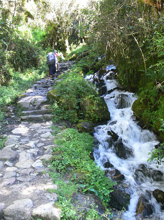 Nice looking trail, if it was not so steep.
The trail continues up along this stream almost to the high point for the day. Again we are surrounded by farms of the Andean people - who live by raising Llamas, donkeys, cows and horses as well as food crops. But for the hiker money, they would be living much as they have for the last 200 years.
There are small bits of original forest, but like the first day this is a hike though farmed land with lots of nice mountains all around you.
For most of the first 5 hours the scenery is not part of the hike - the trail and your breathing are all you are thinking about.
 Its 10am, we have been hiking for 3 hours, and we get a little break for water, chocolate bars, apples.
There is some subversive muttering going on here - but we have a problem and no solution that we like. The problem is the climb. It is just us and the hill. No matter how much you paid for the trek, right now it comes down to you and the hill.
Much as you would like another option, there is only one - back on the trail. Sigh!
 Here is Brenda on the last bit of the climb.
We are above the tree line, with just some tussock grasses. The farms stopped some time ago, but the land is pretty barren. No ancient forest, no modern farm. The mountains would take your breath away, if you had any.
Fabulous scenery though, looking down this valley to the green area at the bottom where we started the climb. Unfortunately, people are mostly looking at the trail in front of their feet. Breathe in, small step, breathe out, small step, ...
 Slog, slog, puff, puff, mutter, mutter, ...
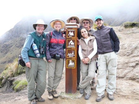
And before you know it, 6 happy people at the high pass!
Nigel and I moved at about the same pace. We had several conversations along the way. They all have the same theme - how could we have let the women talk us into this hike? Nigel swore he was hanging up his hiking boots after this hike - there would be no repeats of the Inca Trail for him.
Alejandro, on the right, was a strong hiker and carried all his equipment in his pack. He stayed back with us and carried his wife's pack up the last bit of each part of the trail.
We had finished the climb and were tired, very tired. Amazingly though, no one had any pain other than fatigue.
 Over the top and down 600 metres to the second camp.
This valley has not been farmed, so this is all native vegetation. Pretty small still, because of the elevation, but native trees and flowers.
We are still walking on restored trail, and the steeps are pretty tall in many places, so it is still hard going.
The 600 metre descent to the camp took about an hour and a half.
We had a meal when we got there, but some were too tired to eat - they had a siesta before dinner instead.
This campsite was not as comfortable as the previous one - hard, stoney ground on a slope. During the night we slid to the low side of the tent in a little heap. Hard day, hard night.
 Near the end of the descent I noticed this red caterpiller going up the next day's ascent.
Well, not a caterpiller after all! This is a group of porters for the Llama Path company heading on to their next camp. They worked on a different schedule from us, and used different camps.
All their porters wore the same red and black outfit - shoes, pants, shirts, packs. When they were packed up they set out on the trail in a group and ran along together. I will look this company up when we get home and find out how much you pay to have a red caterpiller carry your stuff.
You saw our porters - soccers jerseys, shorts, sandles. Almost all the porters dress like that, although some companies try just a little harder to have a more uniform appearance. Most of the porter's packs as well are just bits of nylon tarpaulins tied up with rope or bungie cords.
Day 3 - Pacaymayu to Winaywayna
 We start with about 400 metres uphill, then a long slow drop of 1,200 metres to the third camping spot.
This section of the trail has some original Inca era paving stones. The steps have shorter rises, the surface is generally better for hiking.
Unfortunately the clouds dropped down and we spent the day with on and off showers.
Our group was generally pretty upbeat about the hike (Nigel still says this is his last hike).
 This is what the trail looks like in the rain.
This is the early morning section of the third day. This is original Inca paving - much more effort went into stone selection and placement. If our guide is to be believed, the trail has lasted until now. It could well have lasted on the earlier section but I expect that the locals used the stones for other purposes once the authority of the Inca was ended by the Spanish.
The steps were a little smaller but we were so tired from the previous day's climb that the 600 metre ascent today was pretty tough as well.
 The Inca (no south american indians had a written language) did not have a written language! How do you run an empire when you cannot send written orders to the various areas? Well, they ran it by running. Messengers took oral messages to various places along the Inca trails (there were many such trails all over Peru, not just this one trail). They were expected to run about 25 kilometres a day along these trails. They were fed at the various stations along the way.
During our hike we passed over a dozen Inca runis like this one. Usually small, they were administrative posts, observation posts (spot the enemy and run back to tell the nearest military post) and food storage posts.
Here the group is getting a bit or Inca history from our guide. The 5 Argentinians on the left (bit of red is the fifth), then the two young British backpackers, then Brenda. The white hat is Nigel and I guess Judy beside him. The guide is partly hidden by Nigel's hat.
With no written language, how do we know what was going on back then? In fact, we don't. What the guide told us appears to be largely guesswork based on the few bit of rock left behind. The Spaniards conquered the Incas quite easily - horses and steel swords allowed small groups of Spaniards (usually less than 100) to quickly defeat large groups of Inca led natives. Having conquered, they set about destroying the Inca culture as quickly as they could. Not much survived. (The same strategy was used in Mexico. Did we do any better in North America?)
 Two hours later and it is raining again and we are at another ruin.
The ruins did not survive 500 years in this condition. They were overgrown by the time they started to restore the trail and the ruins along it. I think restoration here was limited to removing brush and a little tidying up. This valley was far enough from the remaining indigenous farming areas that the rock was never removed for use elsewhere. So, after the Spanish conquest the buildings just sat - the roofs disappeared with time since they were made with wooden poles and straw. The walls survived.
It is too bad it rained most of this day. This valley has old growth forests - not large trees because of the altitude, but at least trees original to the area rather than farm fields and grazed over hillsides. We did not see very much of it in the rain though. I guess at this time of year (just after the rainy season) you have to expect one day of rain on a 4 day hike.
There are three levels of stone work in Inca ruins, with this being the middle level. The top level is for buildings in which the Inca royalty lived. The middle level for less important buildings, the lower rustic level for ordinay people. Lots of royal level stonework at Machu Picchu.
 An hour and a half later and it is raining again.
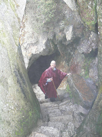
The trail almost always runs along the face of the hill. Here they got into some problems with large rocks which had spilled down the hillside, so built the trail through the rocks and through a natural cave.
Walking in light rain seems to agree with Brenda - she is having a great time.
 An hour later and it is raining a little harder and we have reached another ruin - Phuyupatamarka if you are following the maps.
It is around 12:30 and we have been walking for 5 hours! We had a lunch break around 10am for an hour, which fortunately was the period of hardest rain in the day.
The group is moving along the trail more or less together, which must mean it is a farly easy hike. At each ruin we get a little history and the guide gets reassured that he still has his entire group on the trail.
 You might be tired of stone walls already, but this ruin is a little better than the rest - this wall in particular is almost of royal quality.
The Inca travelled along this trail back and forth to Machu Picchu. Since this particular ruin has this fine stonework, the Inca must have spent some time here on each journey.
There is something I find very puzzling about these royal walls - the combination of very close fit and the occasional somewhat random design. The third stone from the left in the third course of stones from the top is an example - it is taller than the stone on the left. This means that they had to shape the lower course to accept this larger stone. Or, if they built the lower course first, they must have planned on having this larger stone the next course up because they made the lower course smaller. The stones lower down are strange as well.
Is it possible that this part of the wall failed at some time and they filled it back in with less well chosen rocks, but still took the time to make them fit well?
The wall does not seem to be the product of any rational building process!
Other walls from Inca times, walls using much larger rocks, show a similar design approach. At some point along a pretty regular wall there is a rock that is the wrong size for the current pattern but they use it anyway. This means they have to build quite an irregular wall for a group of stones, but that does not seem to matter. What could have triggered such a decision?
 The trail continues through some wonderful mountains, with natural vegetation, but in the light rain and fog. This could have been a really great part of the hike if we could have seen anything.
The hike passes through a number of very distinct ecosystems, each with its own set of plants and birds. The big disappointment of the hike, for a birder, is that there is almost no chance to actually look for birds. With a porter passing every minute or two, there are no parts of the trail free from human disturbance for more than a couple of minutes. The birds that are in the area don't spend much time near the trails.
As you can see in this picture, the trail is well paved with fairly large stones. While rising here, it does not rise too fast for more or less comfortable hiking. We are still at an altitude - between 11,000 and 12,000 feet - that means climbing even gentle inclines requires a lot of puffing. Pretty nice place for a hike though, even in the light rain or fog.
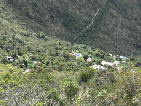
 The third night the campground is at a lodge. There is a place to buy beer, an indoor place to eat (our porters still cooked the meal, but we ate in the lodge rather than in our dining tent), and a few bunk beds. We (Brenda insists it was my decision, I am sure it was something we decided together) could not face another night in the tent on stoney ground, so opted to sleep in the lodge. We got this room with 5 bunk beds to ourselves. The other room had 16 bunks and only 1 person using them.
This also meant we could use the shower without lining up for the two showers the other 250 hikers used (those that did).
In spite of this bit of relative luxury, they did stamp our Inca Trail hike documents.
We slept pretty well here and were fresh for the final push onto Machu Picchu in the very early morning.
Day 4 - Winaywayna to Machu Picchu
 The last day we hiked from the lodge (at the left) to Machu Picchu (the green circles at the right).
This is a relatively short hike but involves an elevation gain at the start as we climbed from the lodge to the top of the last pass from which we can see Machu Picchu. The goal is not to arrive before dawn (around 5:30 am) - that would involve hiking this part in the dark - but to arrive at the pass before the sun actually hits Macchu Picchu (around 6:15 am). So, there is a half hour workout ahead.
 It gets a little crazy on the last day of the hike.
Just past the lodge area there is a checkpoint that opens at 5:30 am. So, we all got up at 4:30, had a quick breakfast, and hurried down the trail to the checkpoint, arriving around 5:00 am. We had to wait half an hour, but ours was the second group at the checkpoint, so we were well positioned for the race along the last bit of the trail.
These are the Argentinians in our group. You can see they had to wear headlamps to make their way down the trail to the checkpoint since it is still an hour before dawn! In spite of having slept in their tents, having been roused at 4:30 and fed a hasty breakfast, they are pretty happy to be here!
You can also see that they are dressed for the cool weather along the trail. At this altitude - we are still over 9,000 feet, it is cool early in the morning.
Most of the first few groups of hikers went along this part of the trail very quickly, even though there is quite an altitude gain up to the pass that looks our over Machu Picchu. I bet most of those warm clothes were off and into the pack within the first few minutes along the trail.
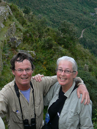 Here we are posed at the Sun Gate, the last pass along the trail before Machu Picchu and our first glimpse of the ruins.
This shot was supposed to include a view of the ruins! Oh well, you will just have to take our word for it that we are at the sun gate above Machu Picchu and not at some random bit of forest!!
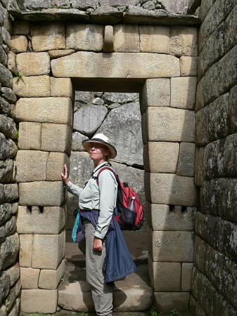 This page is about the Inca Trail hike, not the Machu Picchu ruins, but here is one picture from the ruins that shows the Inca stone work (and an irresistable model doing her Vanna White impersonation).
The door is a little narrower at the top - said to be stronger in the event of earthquakes (common in the area). The stones are well fitted, with occasional design irregularities. The top of the door is a large flat rock - the Incas did not figure out the arch or the wheel! A stone age civilization with a fantastic ability to shape rock into walls!
Should you or shouldn't you
In spite of all the effort required and the physical difficulty of climbing at high elevation, I think all the people who started when we did (all 250 or so of them) finished the hike and were pretty happy at the end.For some it was easy, for us it was hard. Hard work while we were hiking but no injuries, no blisters, just very tired muscles. Perhaps the people for whom it was hardest appreciated the accomplishment more.
That is not to say I would do this hike again. It is good training for other high altitude hikes though - Mt Kilimanjaro for example.