 This altitude map shows the key spots along the trip. The vertical is correctly scaled showing the altitude at each point. The horizontal is scaled by day, not by distance.
We start at Machame Gate early Dec 31, walking to Machame Hut that day. Jan 1 to Shira Hut, Jan 2 to Baranco Camp, Jan 3 to Kranga Valley Camp, Jan 4 to Barafu Camp. At midnight we start up to Stella Point and on to Uhuru Peak around sunrise, continuing on down to Mweka Camp during daylight on Jan 5. Jan 6 we walk out to Mweka Gate. The survivors get Champagne - a pretty powerful incentive for Brenda.
At least that is the plan.
 Yep, like all those other goofs who take a picture by holding the camera at arms length and firing off pictures until one works.
This the the first flight, Victoria to Seattle. We are feeling pretty good.
The rest of the flights went pretty was as expected - long and boring. The KLM flight from Amsterdam to Kilimanjaro airport was a little exceptional. KLM puts more seats per section than any other airline I have been on.
Perhaps we should have moved up market a little on the flights.
However, we got there in one (slightly cramped) piece, were eventually picked up by our safari company and delivered to our upscale hotel - the Colobus Mountain Inn
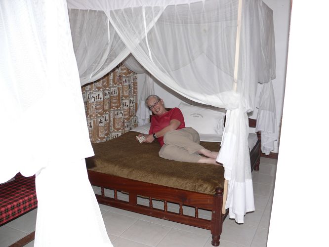 where we had a small building to ourselves. The beds have mosquito nets, which the locals tell us we won't need because there are no mosquitoes. They have nets but no mosquitoes?
Turns out for people from Vancouver Island where we really don't have mosquitoes, these nets are a good idea.
During our stay it was usually between 23C and 27C, with a few windy days or nights. Pretty comfortable except in direct sun.
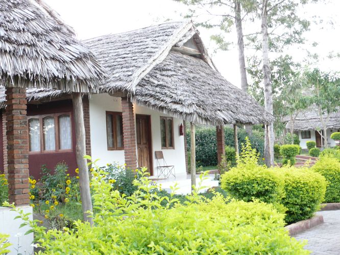 Fortunately, our building had a nice porch with a full roof to keep us cool.
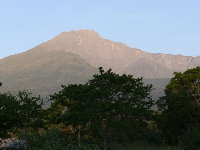 Not Kilimanjaro, Mount Meru! The hotel is at the entrance of Arusha National Park. Mount Meru is the second tallest mountain in Tanzania and is a highlight of ANP, along with small herds of big animals - giraffes, water buffalo, elephants, ....
This is the view from in front of our cottage.
 One more view of the cottages at the Colobus Mountain Inn.
 Life goes on around the Inn. Here local woman are doing the early morning water run.
 We went into the nearest big town, Arusha, for supplies the day before the trek.
It is the local trading centre and this is the local wholesale market. People bring in agricultural products and sell them here to retailers. Pretty busy. Most of the locals are waking around, most of the tourists are in vehicles.
 Where we sat around for a couple of hours.
It turns out that the Safari company does not directly employ most of the people who will support our trek. They hire the guide only. The guide hires everyone else. In our case, our guide is named Ezekiel. He brought along 3 friends - Anoch an assistant guide, Ben a waiter, and our cook. All the rest of the porters are hired right at the gate.
I have no idea why, but this process takes about 2 hours. We actually ended up with 7 additional porters for a total of 11 of them and 3 of us.
Another interesting aspect of the setup is that the safari company does not pay the porters, or anyone else for that matter, their entire salary. We were given a list of tips we were expected to give to each type of person - guide down to lowly porter - for each day of the trip. In our case, that added 20% to the cost of the trek.
 This sign at the gate shows the time for each part of the trek.
No one actually does all these pieces. Our five day ascent included trek segments 1, 2, 7, 8, 9, and 10.
That amounts of 26 hours of trekking.
 And here we have Brenda, blithely unaware of the ordeal ahead, relaxing in the dappled sunlight at the gate while fevered negotiations take place over porters.
The dynamic individual snoozing between Brenda and the photographer is Jim, our trekmate.
Jim is from New Zealand, currently living and working in the wastes of Western Australia. He is gathering his strength here for the trek.
 And they are off and ambling along the trail at the start of the trek. That is Jim again, taking a picture of the back trail.
This lower elevation is a rain forest - you can see the large trees in the background. I expect that this area has been logged in the past, but is part of the National Park now. It is a nice forest, good trail. We did not actually get to hiking until almost 2pm.
 It is now 5pm and we have left the rain forest and entered the Lichen forest - all the trees here have lots of Spanish Lichen draped all over them. Many of the trees are head for some reason - their lichen covered skeletons make up the forest around us at the end of today's trek and for most of tomorrow's trek.
The track was pretty good all day, with cloudy/sunny weather and a nice walking temperature.
The trek included an altitude gain of 900 metres. Using the Victoria standard hike of 349 metres (One Mt Finn), we did almost 2.6 MF's up today, no downs.
 We got to the camp just before dark, had dinner and turned in. A nice hiking day even with the altitude gain. We are a little stiff from the plane rides and the rides around the area getting ready for the trek, but they work out and things are going pretty well.
Early next morning Mt Kilimanjaro was visible before the sun came up. This was typical weather - clear in the morning and evening, cloud during the day.
The only snow visible is the glaciers - not much like the picture on the home page. Looking good for our final ascent.
 Here is the first night camp - our life for the next 6 days. The tents are big enough and dry - we had no problems with moisture getting in. The two tents in the foreground are for the tourists, the others for the porters and guides.
We had inflatable "therma rest" to sleep on. Even though they are only an inch thick just over a foot wide, they seem to work pretty well.
 We were on the trail by 8am. It is steeper here and a much rockier trail. In some places it qualifies as a scramble, not at walk.
 In this look back at the camp area, taken 15 minutes into the hike, you can see the small trees that are typical of this part of the hike.
 Two hours into the hike and several trekkers use this rocky outcrop for a short break.
 Another hour or so and the rocky areas are more common. Here is Brenda on an outcrop, waiting for a few porters to pass. The rightmost person in this picture, with the pack and water bottle in his left hand, is our guide Ezekiel.
 It is now 5 hours into the hike, around 1pm, and many of the shrubs are shorter and the lichen has nothing to hang on other than rocks.
Again, it is typical that around this time of the day - 1pm to 4pm - it clouds over. We spend most afternoons in the clouds. This is not a bad thing. We used little sunscreen on the trek and managed to sunburn our lower lips and not much else.
 This is the campsite for the second night - the Shira Cave campsite. We are now at just under 4000 metres, well above the forest and most of the shrubs.
You may be able to tell from this photograph - the campsite is slightly bowl shaped. So? Well, it acts as a natural sound amplifier. During the evening the porters get quite chatty - after dinner when the tourists have retired to the tents. Lying on the therma rest, you can here the individual words the nearest porters of saying, but since you don't know any Swahili you don't know what they are saying. The sounds from the porters a little farther away are just a murmur - a rising and falling sound like ocean waves lapping on the beach.
The sound sort of ebbs and flows and seems to swirl around you.
Or, it could be the altitude!
 The earlier pictures of Kilimanjaro were taken from south of the mountain. After two days we have walked around to the west side of the mountain. This side shows a collapsed part of the crater wall called the Arrow slide (or Arrow something). Some people go up this side - it is the fastest ascent, but it has lots of loose rock and is quite dangerous. We will walk around the south side of the mountain and up the east side.
 This shot, taken about 30 minutes into today's hike, shows the typical alpine plants - that it, mostly rocks.
Anoch, the assistant guide, is walking with us today. Ezekiel usually stayed behind at the start to supervise the porters taking down the tents and cooking stuff, packing it up, and getting the porters moving along the trail.
 An hour has passed and we are into much more ragged hiking conditions - an area covered with lava rocks. Still, the slope is not that bad and we are making good time.
We are well clear of shrubs having only a few tufts of grass and small flowers to distract us from the rocks.
 It is now 12:30 and we are back into the clouds. In a half an hour we stopped for lunch at the Lava Rocks pass - altitude 4700 metres.
Now, if you recall the altitude map at the start, you will know that we expected to do only 150 metres of altitude gain today - 3800 to 3950 metres. What are we doing a 4700 metres? Are we lost? Has the altitude gotten to us?
No, this is the trail that everyone uses on this day of the trek. Not even the Lonely Planet mentions that this 150 metre altitude gain day is the net on the day, not the cumulative on the day. In fact it is 900 metres up (2.6 MFs) and 750 metres down (2MFs). What a revolting development!
 This is our camp area at the end of day 3 - Barranco Camp.
 Early morning shot of us in front of Kilimanjaro.
We have walked part way around the south face - still more west than east though.
There are very limited bathing facilities on the trek. We get a bowl of warm water each morning and evening. It is around 0 degrees celsius in the morning, so we don't take many clothes off to bathe. As a result, we are beginning to look a little scruffy.
But we are cheerful because after that dirty trick on altitude yesterday, we know we have only 300 metres of vertical today - no problem.
 Bzzzzt! Wrong. This is the start of today's hike - the 300 metre wall. You can see people zigzagging up the wall already, although it is only 9am.
 Half an hour and we are about 1/3 of the way up the wall. We have to stop regularly and let porters pass. Some places get quite congested. Even the porters have to scramble on this part.
Ezekiel calls it a monkey climb - most of the time both hands and feet involved.
 Pretty steep in places. Here Ezekiel and Brenda are negotiating a steep pitch.
 It is 11am, a couple of hours into the hike and the clouds have moved in. It is comfortably cool for a hike - steep and hard hiking but not too hot or cold.
 Three hours into the hike and we take a short break for a photo - just us, the rocks, the clouds, and Kilimanjaro up there somewhere.
 After the first 300 metre wall, things have smoothed out into a series of valleys - always up or down, but no more steep bits.
 Almost 1pm and there is just one more valley to cross. Tonight's camp is on top of the next ridge - you might be able to just see a couple of tents.
 A slightly closer look at the valley - it turns out to be fairly deep with a steep ascent on the other side.
It is hard to estimate how much altitude gain and loss we went through today, but it was far more than the net of nominal 300 metres shown in the guide books. At least 3 MFs up, 2 MFs down I would guess.
 Just as we reached the camp it started to hail - a first for the trip. Fortunately we hike slowly enough that the porters are able to get our tent set up well before we arrive.
We just made it to the tent - a little wet, no big problem - before it really started to come down. We spent a nice hour in the tent with hail crashing onto the fly before it stopped and once again
 the clouds moved off and Kilimanjaro was again revealed to these weary trekkers.
We have now moved almost all the way around the south side of the mountain. In fact, we are now east of the crater.
It is now 6pm and time for dinner. Typical dinner is soup, followed by chicken with a starch and a sauce (vegetable stew), followed by fruit. Not 3 star, but filling.
 Toilets. All campsite come with pit toilets - of the hole in the floor variety, not the Canadian bench with a toilet seat on it. We are talking squat and pray you hit the hole.
Some upscale treks bring along their toilets - no squatting for these folks.
Next time we will book with this company.
 Dawn on the 5th day and we can see the face we will ascend - the east face on the right of this picture. Again, crystal clear mornings - a little cold, usually around 0C, but clear and bright.
What I have not included is a picture of the stars - because I could not take it, not because they were not there to see. Every night was clear and crisp. The sky is filled with starts - some very bright.
It is 6am and we are already off on the trek for the day.
 An hour and a half into the day's hike and we are into another valley. Not much here but rocks and the sky.
 A short pause for a photo of Brenda and I, with the glacier on the south east rim of the crater for background. What a beautiful clear morning.
 It is now 8am, two hours into the hike. That is Brenda with Ezekiel ahead of her setting the pole, pole pace. The guides have a basic plan - keep them moving slowly and they will make it to the top. [pole - pronounced po' lee - Swahili for slowly]
There are no bursts of effort, with frequent rests. They would rather you move slowly for 4 hours at a time than you go with faster bursts and frequent rests. Brenda and Ezekiel follow that plan, I tend to go ahead more quickly then stop and wait till they catch up.
 We are at almost 4600 metres - and almost above the clouds forming already today. Not often you get this view other than from an air plane.
 This is the base camp - Barafu Hut. It is 9am, we have been hiking for 3 hours and climbed 600 metres (1.7 MFs) already today.
The usual plan is to do a little climbing in the area of the base camp, go to bed early, then start for the top some time just after midnight. Ezekiel decided that we should instead start right up the hill today. I am not sure this was a wise choice for us.
 The track above Barafu Hut is steep and rocky, but not difficult. We have been climbing for half an hour.
 This is a pretty steady steepish slope and we have now been on it for 2 1/2 hours from the base camp - 5 1/2 hours in total. As usual, the clouds are moving in as the mountain gets its daily white wreath.
 Another hour, it is clearing and the way ahead looks steep but not difficult.
 The base camp still looks pretty close - at 12 times magnification.
 Its almost 2pm and the glacier on the south east slope is looking pretty close.
 Its now 2:20pm and the thunder on the horizon is getting worse. Worse the snow has started and we are still not at the crater rim.
The guides insist the rim is just a little bit ahead. Just a few more minutes.
 Its 3pm and the rim, also called Stella Point, is just a bit farther ahead. It may well be, but it is not part of our trip. We turned around here and headed back down the hill.
 It is 4pm and we are part way down the hill, snow still falling.
 We made it back to the base camp, 4600 metres, by about 5:30pm, had dinner and tumbled into our sleeping bags, pretty tired.
Our fellow trekker Jim started for the rim at 1 in the morning, made Stella Point by 4am, went into the crater to get away from the cold, went up the crater wall to Uhuru and then back down to the base camp by shortly after 8am. He insists he is not tired or aching.
Jim keeps up the New Zealander reputation of being miracle trekkers.
 We started our descent at around 11:30 - Jim got back a lot sooner than the cook expected and we had to wait two hours for breakfast!
 Half way down - from 4600 to 3800 in by 1:30pm. The way down is a bad track - it seems to be much more washed out than any other track we have been on.
 We are back into the lichen forest - beautiful in a strange way.
 The clouds lift a bit and we can see the rain forest and the next camp.
 We end day 6 still in the lichen forest, at Mweka Camp.
 Day 7 begins with the porters singing the Kilimanjaro song for the trekkers.
From their dress you can tell it is a little cool for them early in the morning.
Ben, our waiter and part time guide, is 6th from the left. Anoch, the assistant guide is second from the right.
 As we neared the end of the hike, we finally found the perfect hiking vehicle for Brenda!
There are no helicopters on the mountain. If people get hurt this is the only way to get them off the mountain.
 The lower trail, in the rain forest is pretty good. Unfortunately we are tired and it is still pretty slow going.
 The finale - we get our certificates from Ezekiel.
Yep, we have been found to be certifiable.
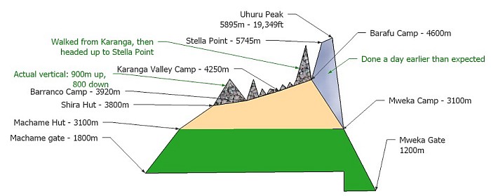 The trek was not quite what we expected from the guide books we had read. This drawing shows what the trip actually was.
There are two major differences. First, on days 3 and 4 we did a lot more up and down than we expected - up to 1000m up and down. The extra vertical is shown by the rock coloured bits on top of the original map. Second, on day 5 we attempted the ascent, rather than resting and trying the final ascent in the dark on day 6 - again, shown by rock coloured bits.
 This is a Tropical Boubou sitting on an Agave plant. If you look closely at the tip of the spike the bird is sitting on you can see a small lizard type animal. The Tropical Boubou has impaled the lizard on the spike. It then nibbled the bit above the spike. It then moved the lizard up a little, impaled it again and had a few more nibbles. I have heard that this family of birds impaled its victims, but this is the first time I have seen and photographed it.
 A few bird highlights of the climb - although there were not a lot of birds in most of the areas we trekked.
This is a Moorland Chat (aka Alpine Chat). These little guys were pretty common above the tree line - often watching us from rocks or bushes.
 This small brown bird with a white throat is a Hunter's Cisticola. I had a lot of trouble figuring this out from my guide books. Fortunately the owner of the Tanzania birds website helped my out. They have great pictures of many of the birds of Tanzania.
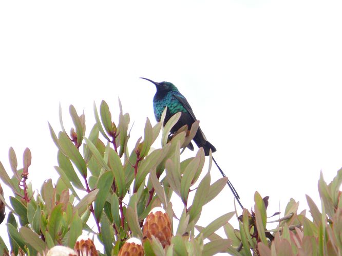 This is a male Red-tufted Sunbird (also called Scarlet-tufted Malachite Sunbird). This species appears to favour the Protea plants that occur only in a restricted altitude range on the Mweka trail - the trail down from the peak. I mistakenly though Protea occurred exclusively in the Cape Town area in South Africa. Two species occur in Tanzania - one on Kilimanjaro and one in the south of Tanzania.
 This is the less ostentatious female Red-tufted Sunbird on a Protea flower.
Apologies for the blown pictures. The abrupt transitions from the darkness of the forest to the back light conditions were too much for me. I will have to learn how to use a few more features of this camera.
 According to our guides, there are only two species of monkey in Kilimanjaro National Park. This is the Blue Monkey - a species we saw only a couple of times during the trek. This one was with a group of about 10 at the Machame Gate at the beginning of the trek.
 This is the Black-and-white Colobus Monkey - which we saw just before the end of the trip at Mweka Gate. There were about 8 monkeys in the group just sitting around resting after a tough day eating fruits and berries.
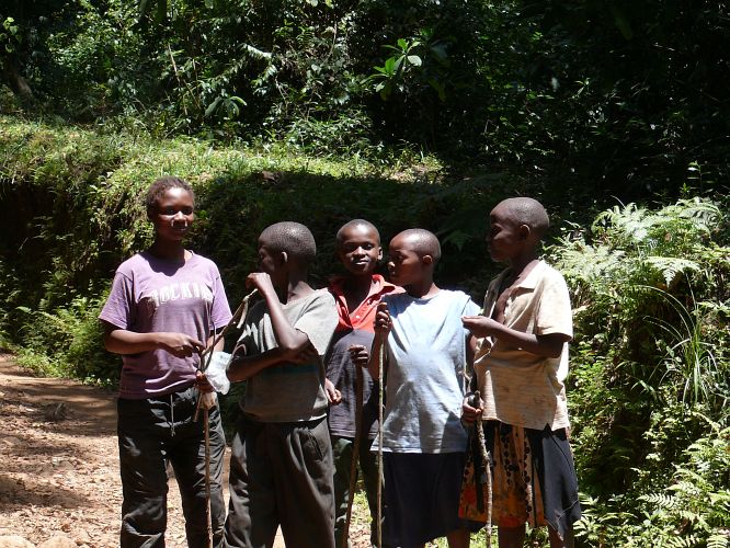 And these are the local kids who pointed out the Colobus Monkeys to us.
We were quite close to the end of the trek at this point. We had seen a couple of other groups of kids - usually collecting fodder (ferns, vines, grass) and taking it out of the park to feed domestic animals.
We had to surrender the last of my Christmas mixed nuts as a reward to these kids.
 We saw this little chipmunk like rodent at the top of the pass - 4700 metres - on day 4. We also saw them at the base camp. Its common name is four-striped grass mouse. These mice have moved up the mountain with the trekkers - populations have increased as trekking has increased. At some regular camp sites they are very common.
Some treks stop at this pass and spend the night - high level acclimatization. Some treks also spend the night in the crater at the top - 5500 metres or so. That would be a challenge.
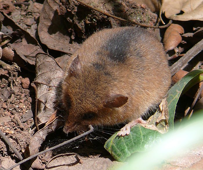 We saw this little shrew or mouse in the low lands near the end of hike down the mountain. It is playing possum here - sitting still hoping we don't see it. What animal is this?
In 2011 while looking back over these pictures, I noticed the huge foot. Looking down from the right ear you see a large pale foot with lobed toes. Looking again through the mammal book I noticed the Climbing mouse picture. Hunting around a bit, I found that Kilimanjaro has the Montane African Climbing Mouse (Dendromus insignis). Also known as the Remarkable Climbing Mouse. There are no pictures on the net that Google knows about! Mystery solved.
The transitions are quite abrupt, not the gradual change you might expect. The plants here are from all 3 zones, but in the order we encountered them. So, rain forest, lichen forest, tundra, lichen forest, rain forest.
 There are two varieties of Impatiens plants on Kilimanjaro - this yellow/orange one and a blueish one. This one is quite common at lower levels. This might be called the Kilimanjaro Impatiens.
 This fascinating plant begins like this - leafy spread out and trapping water in the inner leaves - something like a bromeliad. Its botanical name is lobelia deckenii. Interesting, it appears to have no common name. The plant at this point is about 1.5 feet wide (0.5 metre) and half that tall.
 At some point it gets excited and produces this flower spike. This spike is about half as tall as some others we saw. Above each one of the triangular leaves there is a small trumpet shaped purple flower.
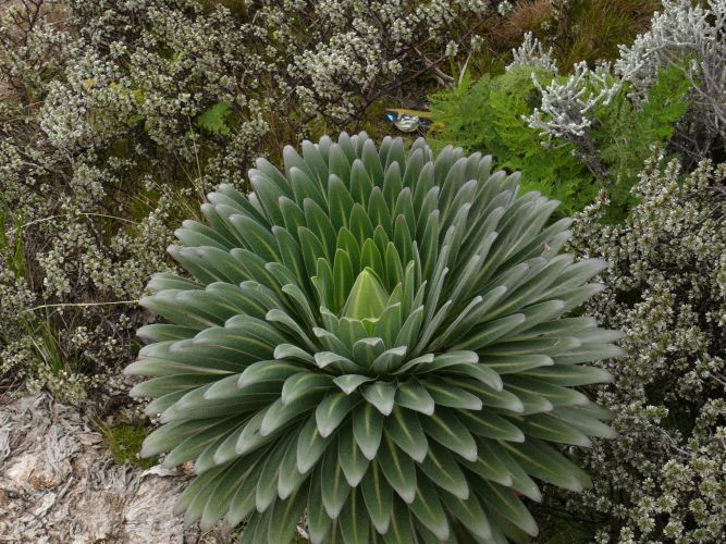
The most common alpine bird - the Aline or Moorland Chat - is checking out one of the flowers. The lobelia depends on this chat and the Scarlet-tufted Malachite Sunbird for pollination.
This plant is only found on Mt Kilimanjaro.
 A variant of this plant with a very similar flower spike occurs farther down the mountain, in the lichen forest.
Here Jim poses with the plant to show how tall he is. If you know Jim, you also know how tall the plant is.
 OK, you have seen enough of this plant by now - just one more picture showing the blue flowers.
This lowland version of the lobelia deckenii appears to me to be a different form of the plant, possibly a different species. Or, it may grow differently in the relative darkness of this alpine forest.
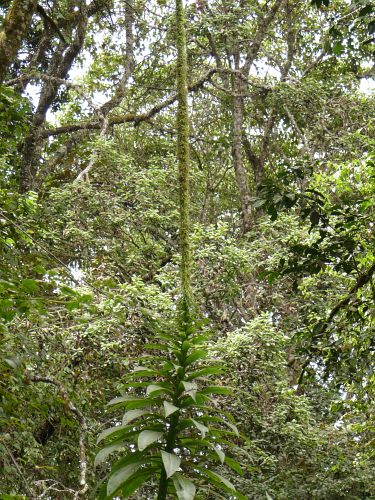 And, while on the subject of flower spikes this remarkable specimen from the rain forest near the end of the hike. This looks like a Dracena to me. The flower spike is about 15 feet (5 metres) tall.
 Once into the alpine zone, but below the area which is mostly just rock (around 4000 metres), there are some forests of these rather strange plants - called giant senecio (Dendrosenecio kilimanjari). Some form candelabra structures, some just single spikes. This species is endemic to Mt Kilimanjaro and a few nearby mountains.
The four-striped grass mouse shown above uses the dead leaves to makes its nests (under rocks).
 This is the flower stalk of the other common and very obvious plant in the alpine. Rather untidy and not very interesting. We saw hundreds of these plants but only 2 flower stalks.
 On the track out of our 4th camp the heather like plants formed themselves into snow drifts. Growing from a central point they seem to spread out and uphill over the years. The result is the scalloped effect.